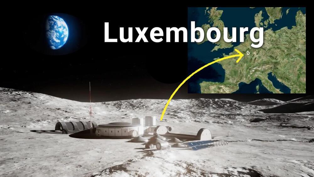
With a decades-long track record of making space a profitable business, Luxembourg is betting big on everything from space resources, satellites and training the next generation of space entrepreneurs.

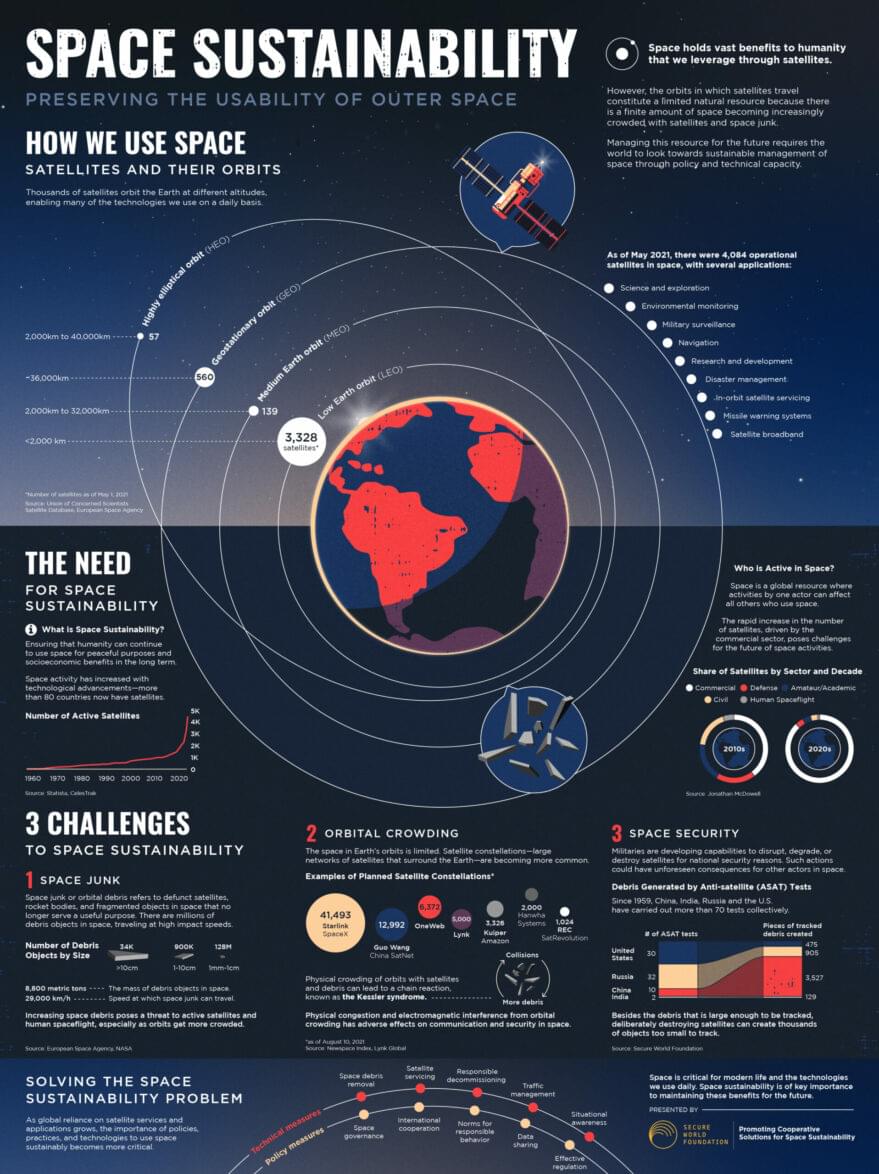
For more than 50 years, near space has been viewed as a vast resource to exploit with few limits. In reality, near space is a very scarce resource. While international agreements such as the Outer Space Treaty and the Registration Convention take steps to protect this precious resource, no single global body is responsible for ensuring the long-term sustainability and safety of near space.
The current surge in the exploitation of outer space means that this lack of a global framework for space sustainability must be addressed immediately, or it will be too late; near space will be cluttered and unrecoverable. We are seeing increased use of near space for tourism and other business ventures and the deployment of megaconstellations comprising tens to hundreds of thousands of satellites. And this is just the start. Last month, we witnessed a Russian anti-satellite test that left portions of near space cluttered with orbital debris. Failure to implement a global framework with an enforcement mechanism for space sustainability could severely impact the ability to fully utilize the resource in the near future.
Today near space activities are subject to disparate space sustainability requirements, generally reliant on the requirements of the object’s launching state or conditions imposed by countries in which entities have market access. Some countries have developed well-crafted requirements for at least some space objects, but others have not. In addition, except for the items covered in existing treaties, like launching state liability, there is almost no harmonization on requirements, which further jeopardizes space sustainability.

SEOUL, South Korea — Malaysia is developing a national space blueprint to drive the growth of its space sector, particularly the manufacturing of remote-sensing satellites, satellite components and data-driven downstream services.
During a Dec. 13 parliamentary hearing, a deputy minister shared the latest update on the “Malaysia Space Exploration 2030” blueprint being fleshed out by Malaysia’s Ministry of Science, Technology and Innovation.
The deputy minister overseeing the effort, Datuk Ahmad Amzad Hashim, said the blueprint outlines a 10-year strategy in line with Malaysia’s National Space Policy 2030. The policy, adopted in 2017, recognizes the importance of space technologies for the country’s economic growth and national security.

WASHINGTON – The National Geospatial-Intelligence Agency has selected a team of commercial and academic partners to build an artificial intelligence system with synthetic data, which will further help the agency determine how it builds machine learning algorithms moving forward.
Orbital Insight was issued a Phase II Small Business Innovation Research contract by the NGA, the company announced. Dec. 16. It will collaborate with Rendered.ai and the University of California, Berkeley, to develop a computer vision model.
As the organization charged with analyzing satellite imagery for the intelligence community, NGA has put increased emphasis on using AI for its mission. The agency sees human-machine pairing as critical for its success, with machine learning algorithms taking over the rote task of processing the torrent of satellite data to find potential intelligence and freeing up human operators to do more high level analysis and tasks.

Stanford’s made a lot of progress over the years with its gecko-inspired robotic hand. In May, a version of the “gecko gripper” even found its way onto the International Space Station to test its ability to perform tasks like collecting debris and fixing satellites.
In a paper published today in Science Robotics, researchers at the university are demonstrating a far more terrestrial application for the tech: picking delicate objects. It’s something that’s long been a challenge for rigid robot hands, leading to a wide range of different solutions, including soft robotic grippers.
The team is showing off FarmHand, a four-fingered gripper inspired by both the dexterity of the human hand and the unique gripping capabilities of geckos. Of the latter, Stanford notes that the adhesive surface “creates a strong hold via microscopic flaps — Van der Waals force – a weak intermolecular force that results from subtle differences in the positions of electrons on the outsides of molecules.”
We’re sending a new pair of X-ray eyes into the universe!
NASA’s Imaging X-ray Polarimetry Explorer (IXPE) is our first satellite dedicated to measuring the polarization of X-rays. Polarized light is made up of electric fields that vibrate in a single direction—and IXPE’s state-of-the-art X-ray vision will help scientists study the spin of black holes, the magnetic fields of pulsars, and other cosmic phenomena.
IXPE is targeted to launch at 1:00 a.m. EST, Dec. 9 (06:00 UTC), aboard a SpaceX Falcon 9 rocket from NASA’s Kennedy Space Center in Florida.
Learn more about the mission at: http://www.nasa.gov/ixpe
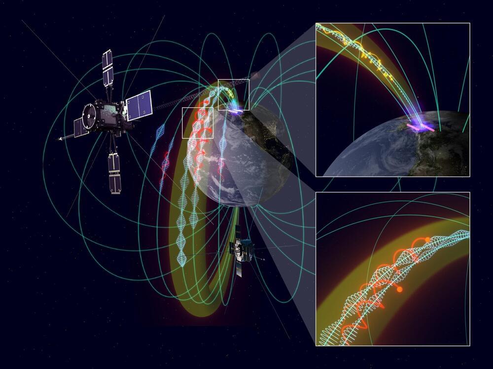
Using data on electromagnetic (EM) waves and plasma particles measured simultaneously via multiple satellites, an international collaborative research group has discovered the existence of invisible “propagation path” of EM waves and elucidated the mechanism by which EM waves propagate to the ground.
It is known that various kinds of EM waves occur naturally in geospace and cause variations in the plasma environment that surrounds the Earth via a physical process known as wave–particle interaction. In particular, when geospace storms occur due to disturbances of sun and solar wind, EM waves become more active, and variations of geospace environment sometimes, may cause damage to spacecrafts, expose astronauts to radiation, and cause terrestrial power grid failures. To understand variation in the plasma environment caused by EM waves in space, in-situ measurement has been performed in space using spacecrafts, such as the Japanese geospace satellite Arase.
As EM waves in space propagate far away from their origin, to correctly understand the effects of EM waves, it is crucial to understand where in space the EM waves are generated and how they are propagated. However, it has been difficult to unravel the origin of EM waves and the mysteries of how EM waves spread spatially using only single-point observation. “Electromagnetic ion cyclotron waves (EMIC waves),” which are the focus of this study, are an important class of EM wave in geospace that control variations in the geospace plasma environment. The source region of ion mode waves has a finite spatial extent, and generated EMIC waves are considered to propagate north to south along the geomagnetic field lines. The specific spatial size of the EMIC wave source region and the 3D aspect of how the propagation path is formed from space to ground are yet to be elucidated.
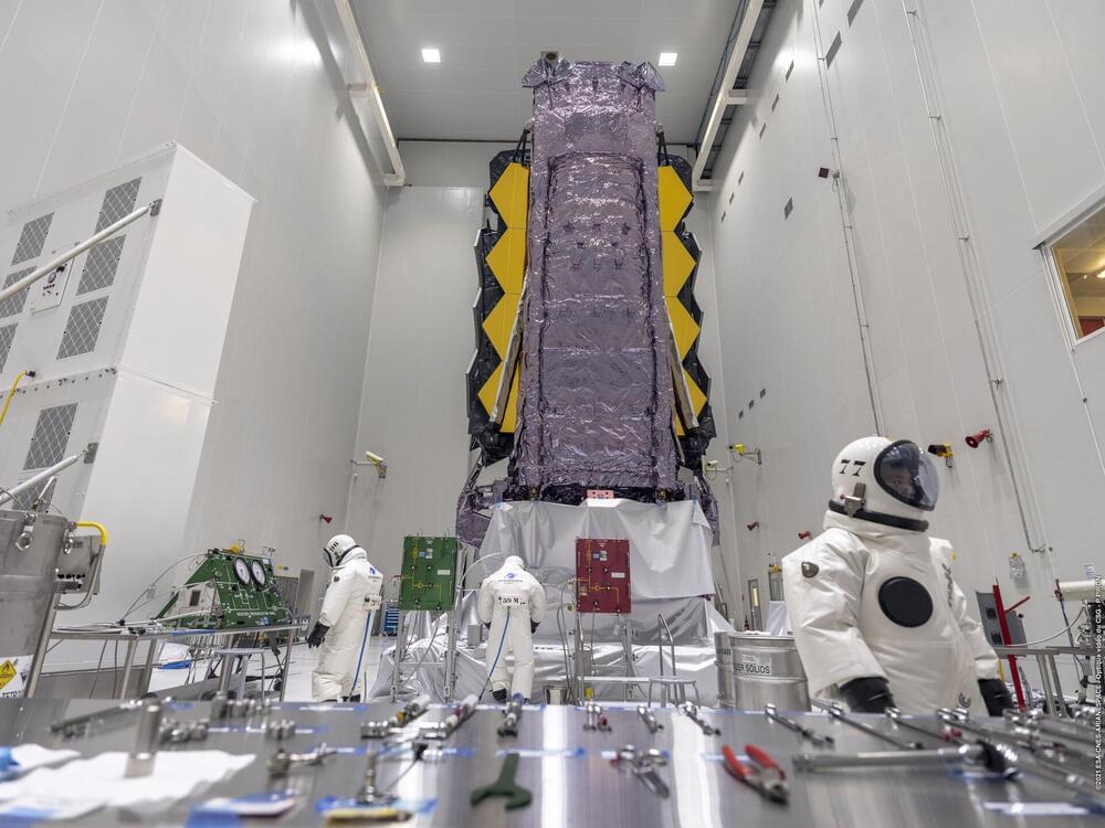
After many MANY delays, the James Webb Space Telescope is fully-fueled and ready for the final stage of preparations before launch (still on for Dec. 22nd)!
On Oct. 12th, 2021, after years of waiting and cost overruns, the James Webb Space Telescope (JWST) finally arrived safely at Europe’s Spaceport in Kourou, French Guiana. The crews began unboxing the next-generation observatory and getting it ready for integration with the Ariane 5 rocket that will take it to space. Then, an “incident” occurred where a clamp band suddenly released, sending vibrations throughout the facility. Once again, the JWST’s launch date was pushed back while crews investigated the source of the problem.
But lo and behold, the due diligence is now done, and the James Webb is back on track! According to the latest news from the ESA, crews have finished fueling the JWST’s thrusters in preparation for its launch, which is scheduled for Dec. 22nd. The Webb will use these thrusters to make course corrections after separating from the Ariane 5 rocket in orbit, maintaining its prescribed orbit, and repointing the observatory during operations.
The process took place in a dedicated fuelling hall at the Centre Spatial Guyanais (CSG) and took ten days to complete (from Nov. 23rd to Dec. 3rd). The reason it takes so long is that fuelling a satellite requires extensive setup and preparation. Equipment and connections need to be set up in advance, safety protocols must be followed to the letter, and the fuel tanks must be pressurized.
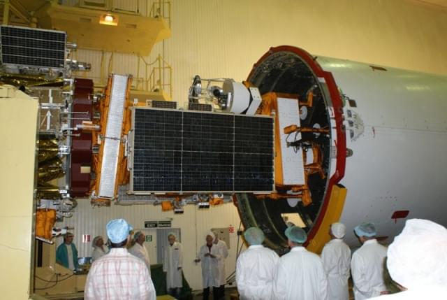
The South African satellite, SumbandilaSat (Pathfinder in Venda) is reaching the end of its life and will deorbit on Friday 10 December 2021.
The satellite was launched in 2009 and took a total of 1,128 high-resolution, usable images. In addition, these imageries were applied in local research and on the Copernicus (previously GMES: Global Monitoring for Environment and Security) programme. The data also contributed towards disaster management such as flood monitoring in Namibia and fire campaigns in the Kruger National Park in South Africa. Furthermore, it also recorded timely images of the Fukushima nuclear disaster and the Tuscaloosa tornado in the USA.
In May 2005, the then DST (Department of Science and Technology) of the South African Government commissioned Stellenbosch University and SunSpace to develop the ZASat pathfinder satellite program (later renamed SumbandilaSat), a technology demonstrator in conjunction with the South African industry. Consequently, SumbandilaSat was delivered 15 months later and launched from Baikonur, Kazakhstan on September 17 2009 with monitoring and satellite support from the SANSA Space Operations facility in Hartebeesthoek.