Toggle light / dark theme

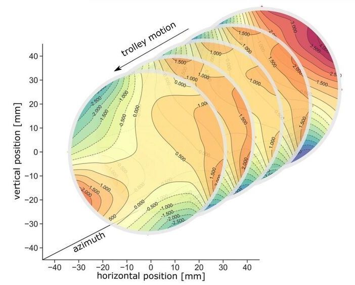
As scientists await the highly anticipated initial results of the Muon g-2 experiment at the U.S. Department of Energy’s (DOE) Fermi National Accelerator Laboratory, collaborating scientists from DOE’s Argonne National Laboratory continue to employ and maintain the unique system that maps the magnetic field in the experiment with unprecedented precision.

Argonne scientists upgraded the , which uses an advanced communication scheme and new magnetic field probes and electronics to map the field throughout the 45-meter circumference ring in which the experiment takes place.

The experiment, which began in 2017 and continues today, could be of great consequence to the field of particle physics. As a follow-up to a past experiment at DOE’s Brookhaven National Laboratory, it has the power to affirm or discount the previous results, which could shed light on the validity of parts of the reigning Standard Model of particle physics.

For many, gazing at an old photo of a city can evoke feelings of both nostalgia and wonder — what was it like to walk through Manhattan in the 1940s? How much has the street one grew up on changed? While Google Street View allows people to see what an area looks like in the present day, what if you want to explore how places looked in the past?

We stored the light by putting it in a suitcase so to speak, only that in our case the suitcase was made of a cloud of cold atoms,” says physicist Patrick Windpassinger from Mainz University in Germany. “We moved this suitcase over a short distance and then took the light out again.


The storage and transfer of information is a fundamental part of any computing system, and quantum computing systems are no different – if we’re going to benefit from the speed and security of quantum computers and a quantum internet, then we need to figure out how to shift quantum data around.

One of the ways scientists are approaching this is through optical quantum memory, or using light to store data as maps of particle states, and a new study reports on what researchers are calling a milestone in the field: the successful storage and transfer of light using quantum memory.

The researchers weren’t able to transfer the light very far – just 1.2 millimetres or 0.05 inches – but the process outlined here could form the foundation of the quantum-powered computers and communication systems of the future.

Scientists from Scripps Research and Los Alamos National Laboratory have devised a method for mapping in unprecedented detail the thickets of slippery sugar molecules that help shield HIV from the immune system.

Mapping these shields will give researchers a more complete understanding of why antibodies react to some spots on the virus but not others, and may shape the design of new vaccines that target the most vulnerable and accessible sites on HIV and other viruses.

The sugar molecules, or “glycans,” are loose and stringy, and function as shields because they are difficult for antibodies to grip and block access to the . The shields form on the outermost spike proteins of HIV and many other viruses, including SARS-CoV-2, the coronavirus that causes COVID-19, because these viruses have evolved sites on their spike proteins where glycan molecules—normally abundant in cells—will automatically attach.

Head Image Caption: Street level view of 3D-reconstructed Chelsea, Manhattan

Historians and nostalgic residents alike take an interest in how cities were constructed and how they developed — and now there’s a tool for that. Google AI recently launched the open-source browser-based toolset “,” which was created to enable the exploration of city transitions from 1800 to 2000 virtually in a three-dimensional view.

Google AI says the name is pronounced as “re-turn” and derives its meaning from “reconstruction, research, recreation and remembering.” This scalable system runs on Google Cloud and Kubernetes and reconstructs cities from historical maps and photos.

In this brief, at times controversial— even radical—volume. Dr. Ian C. Hale guides us through likely scenarios and gives us life-saving recommendations for effectively dealing with the next waves of the COVID-19 pandemic. This is a must read for public policy makers, medical professionals, and those mapping out their financial future in the post-corona world.

There are four ways drones typically navigate. Either they use GPS or other beacons, or they accept guidance instructions from a computer, or they navigate off a stored map, or they are flown by an expert in control.

What do you when absolutely none of the four are possible?

You put AI on the drone and it flies itself with no outside source of data, no built-in mapping, and no operator in control.