Toggle light / dark theme

The U.S. space agency National Aeronautics Space Administration (NASA), European Space Agency (ESA), and Japan Aerospace Exploration Agency (JAXA) are inviting coders, entrepreneurs, scientists, designers, storytellers, makers, builders, artists, and technologists to participate in a virtual hackathon May 30–31 dedicated to putting open data to work in developing solutions to issues related to the COVID-19 pandemic.

During the global Space Apps COVID-19 Challenge, participants from around the world will create virtual teams that – during a 48-hour period – will use Earth observation data to propose solutions to COVID-19-related challenges ranging from studying the coronavirus that causes COVID-19 and its spread to the impact the disease is having on the Earth system. Registration for this challenge opens in mid-May.

“There’s a tremendous need for our collective ingenuity right now,” said Thomas Zurbuchen, associate administrator for NASA’s Science Mission Directorate. “I can’t imagine a more worthy focus than COVID-19 on which to direct the energy and enthusiasm from around the world with the Space Apps Challenge that always generates such amazing solutions.”

The unique capabilities of NASA and its partner space agencies in the areas of science and technology enable them to lend a hand during this global crisis. Since the start of the global outbreak, Earth science specialists from each agency have been exploring ways to use unique Earth observation data to aid understanding of the interplay of the Earth system – on global to local scales – with aspects of the COVID-19 outbreak, including, potentially, our ability to combat it. The hackathon will also examine the human and economic response to the virus.

https://www.youtube.com/watch?v=p_quOKBRJKs

ESA will contribute data from the Sentinel missions (Sentinel-1, Sentinel-2 and Sentinel-5P) in the context of the European Copernicus program, led by the European Commission, along with data from Third Party contributing Missions, with a focus on assessing the impact on climate change and greenhouse gases, as well as impacts on the economic sector. ESA also is contributing Earth observation experts for the selection of the competition winners and the artificial-intelligence-powered EuroDataCube.

“EuroDatacube will enable the best ideas to be scaled up to a global level,” said Josef Aschbacher, director of Earth Observation Programmes at ESA. “The pandemic crisis has a worldwide impact, therefore international cooperation and sharing of data and expertise with partners like NASA and JAXA seems the most suitable approach.”

JAXA is making Earth observing data available from its satellite missions, including ALOS-2, GOSAT, GOSAT-2, GCOM-C, GCOM-W, and GPM/DPR.
“JAXA welcomes the opportunity to be part of the hackathon,” said JAXA Vice President Terada Koji. “I believe the trilateral cooperation among ESA, NASA and JAXA is important to demonstrate how Earth observation can support global efforts in combating this unprecedented challenge.“
Space Apps is an international hackathon that takes place in cities around the world. Since 2012, teams have engaged with NASA’s free and open data to address real-world problems on Earth and in space. The COVID-19 Challenge will be the program’s first global virtual hackathon. Space Apps 2019 included more than 29,000 participants at 225 events in 71 countries, developing more than 2,000 hackathon solutions over the course of one weekend.

Philippine developers used NASA’s free and open data to solve real-world problems on Earth and space.

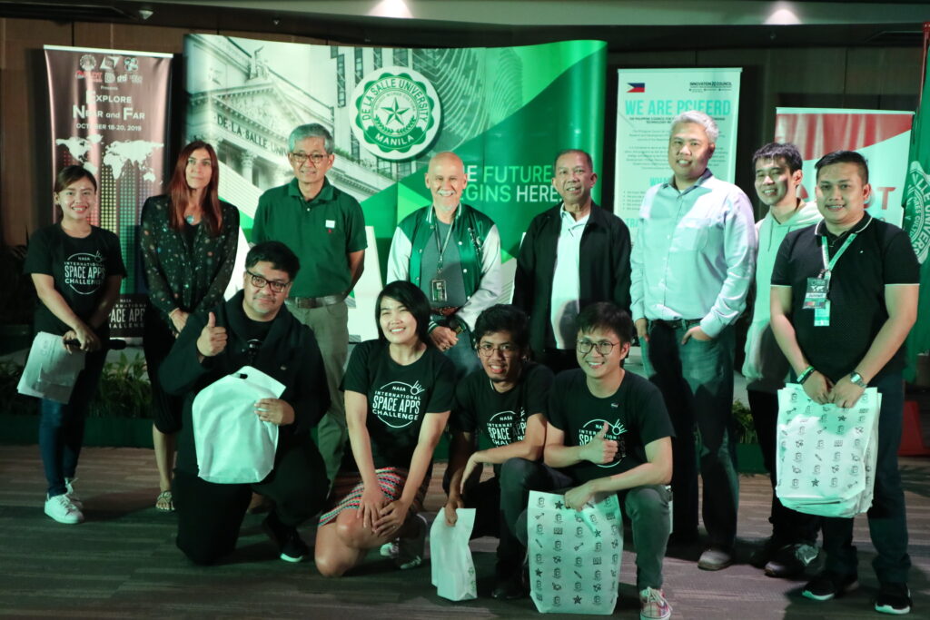
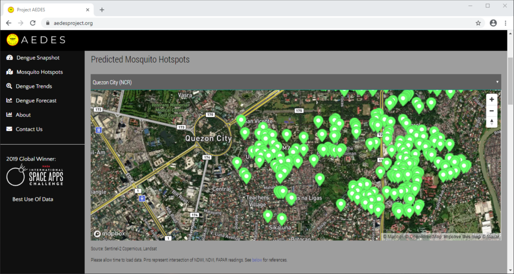
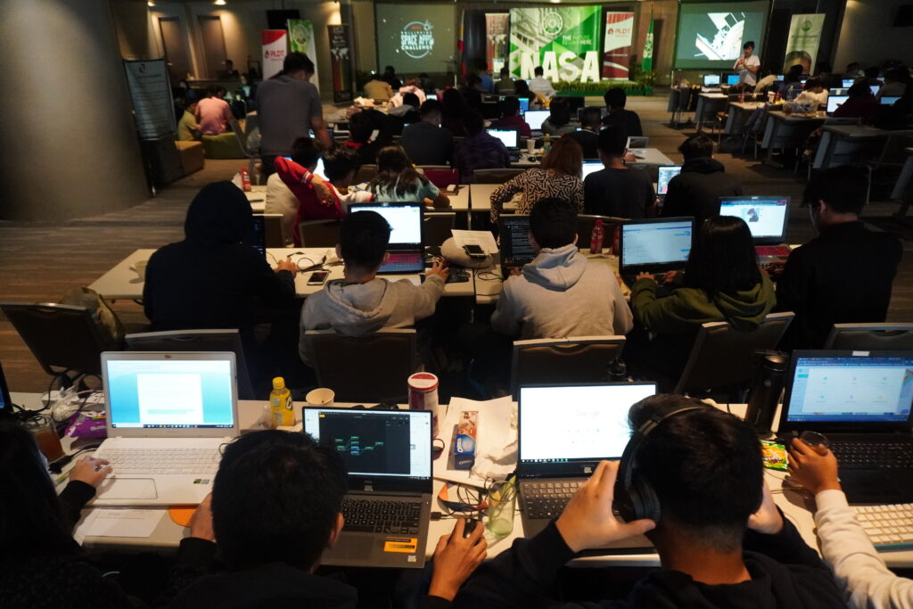
Many Filipinos participated in this annual hackathon since 2016. Recently, a dengue mapping forecasting system was developed by data scientists from CirroLytix using satellite and climate data with the goal of addressing the sustainable development goals of the United Nations. This web application, called Project AEDES won globally for the best use of data. “Earth observation data has the potential to be used in fighting epidemics and outbreaks threatening humanity nowadays, as well as to analyze its socio-economic impact,” according to software developer Michael Lance M. Domagas, who led the Philippine hackathon in collaboration with De La Salle University, PLDT, Department of Science and Technology, United Nations Development Programme, and the U.S. embassy. The very first Philippine winner used citizen science and environmental data to develop a smartphone application informing fishermen the right time to catch fish. ISDApp is currently being incubated at Animo Labs.

Space Apps is a NASA-led initiative organized globally in collaboration with Booz Allen Hamilton, Mindgrub and SecondMuse. The next annual Space Apps Challenge is scheduled for October 2–4.

Registration opens May 12. https://covid19.spaceappschallenge.org/

Upper row Associate American Corner librarian Donna Lyn G. Labangon, Space Apps global leader Dr. Paula S. Bontempi, former DICT Usec. Monchito B. Ibrahim, Animo Labs executive director Mr. Federico C. Gonzalez, DOST-PCIEERD deputy executive director Engr. Raul C. Sabularse, PLDT Enterprise Core Business Solutions vice president and head Joseph Ian G. Gendrano, lead organizer Michael Lance M. Domagas, and Animo Labs program manager Junnell E. Guia. Lower row Dominic Vincent D. Ligot, Frances Claire Tayco, Mark Toledo, and Jansen Dumaliang Lopez of Aedes project.

MANILA, Philippines — A dengue case forecasting system using space data made by Philippine developers won the 2019 National Aeronautics and Space Administration’s International Space Apps Challenge. Over 29,000 participating globally in 71 countries, this solution made it as one of the six winners in the best use of data, the solution that best makes space data accessible, or leverages it to a unique application.

Dengue fever is a viral, infectious tropical disease spread primarily by Aedes aegypti female mosquitoes. With 271,480 cases resulting in 1,107 deaths reported from January 1 to August 31, 2019 by the World Health Organization, Dominic Vincent D. Ligot, Mark Toledo, Frances Claire Tayco, and Jansen Dumaliang Lopez from CirroLytix developed a forecasting model of dengue cases using climate and digital data, and pinpointing possible hotspots from satellite data.

Sentinel-2 Copernicus and Landsat 8 satellite data used to reveal potential dengue hotspots.

Correlating information from Sentinel-2 Copernicus and Landsat 8 satellites, climate data from the Philippine Atmospheric, Geophysical and Astronomical Services Administration of the Department of Science and Technology (DOST-PAGASA) and trends from Google search engines, potential dengue hotspots will be shown in a web interface.

Using satellite spectral bands like green, red, and near-infrared (NIR), indices like Fraction of Absorbed Photosynthetically Active Radiation (FAPAR) and Normalized Difference Vegetation Index (NDVI) are calculated in identifying areas with green vegetation while Normalized Difference Water Index (NDWI) identifies areas with water. Combining these indices reveal potential areas of stagnant water capable of being breeding grounds for mosquitoes, extracted as coordinates through a free and open-source cross-platform desktop geographic information system QGIS.

https://www.youtube.com/watch?v=uzpI775XoY0

Check out the website here: http://aedesproject.org/

Winners visit the Philippine Earth Data Resource and Observation (PEDRO) Center at the DOST-Advanced Science and Technology Institute in Diliman, Quezon City with Dr. Joel Joseph S. Marciano, Jr.

“AEDES aims to improve public health response against dengue fever in the Philippines by pinpointing possible hotspots using Earth observations,” Dr. Argyro Kavvada of NASA Earth Science and Booz Allen Hamilton explained.

The DOST-Philippine Council for Industry, Energy and Emerging Technology Research and Development (DOST-PCIEERD) deputy executive director Engr. Raul C. Sabularse said that the winning solution “benefits the community especially those countries suffering from malaria and dengue, just like the Philippines. I think it has a global impact. This is the new science to know the potential areas where dengue might occur. It is a good app.”

“It is very relevant to the Philippines and other countries which usually having problems with dengue. The team was able to show that it’s not really difficult to have all the data you need and integrate all of them and make them accessible to everyone for them to be able to use it. It’s a working model,” according to Monchito B. Ibrahim, industry development committee chairman of the Analytics Association of the Philippines and former undersecretary of the Department of Information and Communications Technology.

Biological oceanographer Dr. Paula S. Bontempi, acting deputy director of the Earth Science Mission, NASA’s Science Mission Directorate and the current leader of the Space Apps global organizing team

The leader of the Space Apps global organizing team Dr. Paula S. Bontempi, acting deputy director of the Earth Science Mission, NASA’s Science Mission Directorate remembers the pitch of the winning team when she led the hackathon in Manila. “They were terrific. Well deserved!” she said.

“I am very happy we landed in the winning circle. This would be a big help particularly in addressing our health-related problems. One of the Sustainable Development Goals (SDGs) is on Good Health and Well Being and the problem they are trying to address is analysis related to dengue,“ said Science and Technology secretary Fortunato T. de la Peña. Rex Lor from the United Nations Development Programme (UNDP) in the Philippines explained that the winning solution showcases the “pivotal role of cutting-edge digital technologies in the creation of strategies for sustainable development in the face of evolving development issues.”

U.S Public Affairs counselor Philip W. Roskamp and PLDT Enterprise Core Business Solutions vice president and head Joseph Ian G. Gendrano congratulates the next group of Pinoy winners.

Sec. de la Peña is also very happy on this second time victory for the Philippines on the global competition of NASA. The first winning solution ISDApp uses “data analysis, particularly NASA data, to be able to help our fishermen make decisions on when is the best time to catch fish.” It is currently being incubated by Animo Labs, the technology business incubator and Fab Lab of De La Salle University in partnership with DOST-PCIEERD. Project AEDES will be incubated by Animo Labs too.

University president Br. Raymundo B. Suplido FSC hopes that NASA Space Apps would “encourage our young Filipino researchers and scientists to create ideas and startups based on space science and technology, and pave the way for the promotion and awareness of the programs of our own Philippine space agency.”

Philippine vice president Leni Robredo recognized Space Apps as a platform “where some of our country’s brightest minds can collaborate in finding and creating solutions to our most pressing problems, not just in space, but more importantly here on Earth.”

“Space Apps is a community of scientists and engineers, artists and hackers coming together to address key issues here on Earth. At the heart of Space Apps are data that come to us from spacecraft flying around Earth and are looking at our world,” explained by Dr. Thomas Zurbuchen, NASA associate administrator for science.

“Personally, I’m more interested in supporting the startups that are coming out of the Space Apps Challenge,” according to DOST-PCIEERD executive director Dr. Enrico C. Paringit.

In the Philippines, Space Apps is a NASA-led initiative organized in collaboration with De La Salle University, Animo Labs, DOST-PCIEERD, PLDT InnoLab, American Corner Manila, U.S. Embassy, software developer Michael Lance M. Domagas, and celebrates the Design Week Philippines with the Design Center of the Philippines of the Department of Trade and Industry. It is globally organized by Booz Allen Hamilton, Mindgrub, and SecondMuse.

Space Apps is a NASA incubator innovation program. The next hackathon will be on October 2–4, 2020.

#SpaceApps #SpaceAppsPH

Filipino developers gather together to address real-world problems on Earth and space using NASA’s free and open source data.