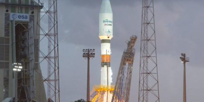
The theme of this year’s World Space Week is satellites improve life. We are taking this opportunity to appreciate satellite technology and its incredible benefits.
Category: satellites
SpaceX launched 60 Starlink satellites atop a Falcon 9 rocket from Pad 39A at NASA’s Kennedy Space Center in Florida on Oct. 6, 2020. The private spaceflight company has now launched well over 700 of these internet-providing satellites into orbit. [SpaceX launches 60 Starlink satellites and lands rocket at sea](https://www.space.com/spacex-starlink-12-internet-satellites-launch)
Credit: SpaceX
#SpaceX just partnered with the U.S. military’s #Space Development Agency (SDA) to manufacture four new satellites that the Pentagon will use to detect and track missiles from space.
The $149 million contract is for four satellites, according to Reuters, which are scheduled to be delivered by the end of 2022. The actual #missile-tracking sensors will be developed by a separate subcontractor and attached to the #satellites later, but the military is hoping to piggyback on SpaceX’s recent success in ramping up satellite production for its #Starlink network.
It’s the first time SpaceX is building satellites for the military.
SpaceX is developing a new satellite bus for the Space Development Agency based on the Starlink design.
WASHINGTON — The Space Development Agency awarded SpaceX a $149 million contract and L3Harris a $193.5 million contract to each build four satellites to detect and track ballistic and hypersonic missiles.
The contracts announced Oct. 5 are for the first eight satellites of a potentially much larger Space Development Agency constellation of sensor satellites known as Tracking Layer Tranche 0. This is SpaceX’s first military contract to produce satellites.
SkyWatch Space Applications, the Canadian startup whose EarthCache platform helps software developers embed geospatial data and imagery in applications, announced a partnership Oct. 5 with Picterra, a Swiss startup with a self-service platform to help customers autonomously extract information from aerial and satellite imagery.
“One of the things that has been very difficult to achieve is this ability to easily and affordably access satellite data in a way that is fast but also in a way in which you can derive the insights you need for your particular business,” James Slifierz, SkyWatch CEO told SpaceNews. “What if you can merge both the accessibility of this data with an ease of developing and applying intelligence to the data so that any company in the world could have the tools to derive insights?”
SkyWatch’s EarthCache platform is designed to ease access to aerial and satellite imagery. However, SkyWatch doesn’t provide data analysis.
Picterra is not a data provider. Instead, the company helps customers build their own machine-learning algorithms to detect things like building footprints in imagery customers either upload or find in Picterra’s library of open-source imagery.
China is pushing ahead with developing a giant Low Earth Orbit (LEO) satellite constellation competing with SpaceX, Amazon and OneWeb, according to the Washington DC-based analyst Bhavya Lal and California State University’s Professor Larry Press.
Press, professor of information systems at the California State University, mentioned a recent Chinese spectrum filing in a blog of the CircleID website. China “has filed a spectrum application with the International Telecommunication Union for two constellations with the cryptic names GW-A59 and GW-2″ for a total of 12,992 satellites, Press said.
“We heard about an announcement of a constellation with nearly 13,000 satellites,” Bhavya Lal said in SpaceWatchGlobal’s Space Café webtalk last week. Lal is a senior space policy analyst at the IDA Science and Technology Policy Institute in Washington DC and was in the lead for IDA’s recently published report “Evaluation of China’s Commercial Space Sector”.
“Out of around 20 Chinese companies engaged in satellite communications, fewer than a half dozen have proposed constellations,” Lal summarized the report’s findings. “Many focus on narrowband communications, targeting markets such as the Internet of Things (IoT).” Companies considering satellite broadband at an early stage include LinkSure and Galaxy Space, Lal said, while state-owned enterprises such as CASIC and CASC “have the deeper pockets needed to more rapidly launch satellite constellations”.
Regarding the not state-owned enterprises (SOE’s) “we found that these broadband companies are all very early-stage, still in the R&D phase, and do not have much in the way of hardware to launch,” Lal said. “However, as in other areas, the Chinese are making fast progress. The best we can tell the current focus of most companies is domestic. But as the Chinese have done in other areas such as high-speed rail, it would be not a stretch of the imagination that once the bugs in the system are worked out domestically, the Chinese will begin to market services internationally.”
 Paris, 4 October 2020. – A New York court has confirmed OneWeb’s rescue plan and put it back on track to launch its services in 2021, the London-based LEO operator announced.
The U.S. Bankruptcy Court for the Southern District of New York confirmed OneWeb’s Chapter 11 reorganization plan, ensuring that the company remains on target to resume business operations and deploy the initial 650 LEO satellite constellation under its new ownership, OneWeb said.
“The transactions outlined in the Plan will be implemented following receipt of customary regulatory approvals, which are expected by the end of 2020. In the meantime, OneWeb is resuming operations and readying its commercial services which are planned to start next year.”
#SpaceWatchGL Opinion: Satellite Technologies Use To Monitor Climate Change and Manage Environmental Disasters
Posted in climatology, economics, existential risks, habitats, satellites, sustainability | Leave a Comment on #SpaceWatchGL Opinion: Satellite Technologies Use To Monitor Climate Change and Manage Environmental Disasters
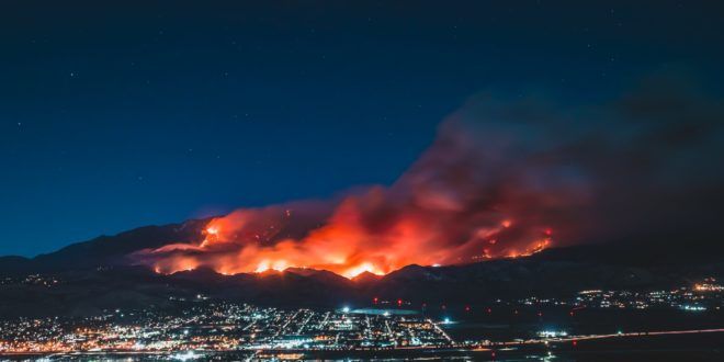
The recent 2020 US West Coast wildfire has opened infernos, as it ravaged hundreds of homes and charred hundreds of neighborhoods. On September 10, 2020, CNN announced that the Creek Fire had taken more than 166,00 acres after destroying 360 structures in Central California, Amidst a state emergency, firefighters had to defeat the “beast” that turned the scenery to a similar fiction movies scene on a doomsday. Wildfire causes environmental disasters that were attributed by many scientists to climate change. The preparedness, detection, and management of wildfires and other environmental disasters, that affected the environment hinge on satellite technologies, essentially, the Remote Sensing of sea surfaces and land areas, and the civil space-based Earth Observation and its applications. Such space-based technologies are deployed to assess, monitor, and manage local, regional, and large-scale transboundary environmental issues that impact the societies, economies, and ecosystems. Thanks to its large areas’ data collection and high-frequency capabilities Earth Observation, in particular, has become a powerful tool to monitor the terrestrial environment and manage environmental disasters as it be addressed in this article.
Satellite technologies have been used to understand climate change better to find solutions to mitigate its deteriorating consequences, such as hurricanes, droughts, rising sea levels, melting polar ice caps, wildfire, and floods. Scientists relied upon various observation systems and satellite technologies, networks of weather balloons, buoys, and thermometer, to collect climate change’s evidence from the depths of the oceans to the top of Earth’s atmosphere. For instance, EO is relied upon to map the greenhouse gases. Earth Observation (EO) monitors the carbon dioxide (CO2) concentration, the second most abundant greenhouse gas component after water vapor, satellite monitored through water management, and weather forecast [1]. Public and private entities harnessed spectroscopy and satellites to monitor externalities data from various sources.
Starlink Render Created By: ErcX @ErcXspace
SpaceX is looking forward to providing Starlink satellite broadband internet service globally. The company aims to initially offer connection in rural areas of the northern United States and Canada before this year ends. A total of 4,409 internet-beaming satellites will initially make up the Starlink constellation; t here are around 708 satellites already in low Earth orbit. SpaceX is Private Beta Testing the network among employees. Starlink users receive broadband service from the satellites in space via a user dish terminal that is easy to install. “The instructions are super-easy. You plug it in, and you point it at the sky, and a few seconds later you have internet. It’s truly remarkable,” Jonathan Hofeller SpaceX Vice-President of Starlink and Commercial Sales said in July.
SpaceX’s Starlink network is also undergoing real world use with Washington state’s unit of first responders, who are helping rebuild after wildfires destroyed the small town of Malden early September. The emergency telecommunications leader of the Washington State Military Department’s IT division, Richard Hall, told reporters he set up Starlink user terminals in locations that are severely devastated by the fires, to provide families broadband access that enables them to perform wireless calls and connect online. In his job profession Hall has set up a variety of satellite services, he stated that “there’s really no comparison” between Starlink and other networks. “Starlink easily doubles the bandwidth” in comparison, “I’ve seen lower than 30 millisecond latency consistently,” he told CNBC news last week. — “Starlink will be a revolution in connectivity, especially for remote regions or for emergency services when landlines are damaged,” the founder of SpaceX Elon Musk said.
Live coverage of the countdown and launch of a SpaceX Falcon 9 rocket from Cape Canaveral Air Force Station in Florida with the U.S. Air Force’s GPS 3 SV04 navigation satellite. Text updates will appear automatically below. Follow us on Twitter.
Read our full story.


